April 25, 2016
Fred and I have been reading accounts about the disappearance of Amelia Earhart and Fred Noonan since we were kids. We have, like so many others, formed many opinions about what transpired on July 2, 1937 in the Central Pacific. First there was the official government statement, she crashed and sank. Then Fred Goerner’s ground breaking work about a secret mission to photograph Japanese installations in the Japanese Mandated Islands. Also, there was Paper TIGHAR’s hypothesis, loudly touted in the media and finally the current popular theory by Richard Spink (Mili Atoll). There have been several good books written on the subject and we have studied them. The problem is that each of the people who have written books, or are currently looking for the Holy Grail (Her Lockheed 10E), or irrefutable evidence of it are very militant and unwilling to listen to anyone who has a different idea. There is a large group of us who are looking at the situation and listening to the groups who are “certain they have the correct answer”. We do not make those claims but we do have some, what we consider, well thought out insights on a portion of the incident.
There is a chain of events that lead to a crash. The chain begins at some point in time before the incident and ends when the incident is over. There is a chain of events related to every good or bad thing that happens to someone. In the case of an aircraft loss, it is a chain that usually can be identified step by step. That is what we propose to do with Ms. Earhart and Mr. Noonan. Each link in the chain has a person or persons responsible.
1. The beginning of the chain occurred between April 29 and May 8, 1937. On April 29, 1937 Ruth Hampton, Acting director of the Department of Interior (DOI) wrote a letter to Richard Black, Representative of the DOI in Honolulu, Hawaii. She detailed a conversation with Amelia Earhart about her upcoming flight from Oakland to Honolulu to Howland Island. Amelia outlined a flight from East to West. On May 8, 1937 George Putnam wrote a letter to Admiral Leahy, Chief of Naval Operations, acknowledging a letter that Leahy had written to Amelia. In this letter Putnam outlined the “reasons” the direction and route of flight was being cAmehanged. They were to go from Oakland to Miami via El Paso and New Orleans. Another letter to Richard Southgate, US State Department, detailed the change in direction and route. These letters were classified and Southgate’s letter was not declassified until December 8, 1995. There is no indication on the declassification date of the Leahy Letter. Southgate answered the letter on May 8th stating that a new letter of authority would have to be issued by the Department of Commerce. A new letter of authority was issued on May 14, 1937. The burden of responsibility for the first link in the chain belongs to Amelia Earhart because she was the commander of the flight and had the last word, go or no-go.
2. George Putnam had put together a large welcome home ceremony and ball in Oakland, CA to take place on July 4, 1937. With the delay at Lae, New Guinea, Amelia lamented the fact that she couldn’t make the July 4th deadline. This was extra pressure applied to an already exhausted and obviously stressed individual. Get-home-itis is a popular phrase to describe it. Because of the change in direction and the fatigue factor, the most difficult portion of the journey (finding an island in a vast ocean that was 8 feet above sea level and 2 miles long by 1 mile wide, was saved for the worst possible time of the entire journey. The addition of the extra pressure to make it to Oakland by the 4 was the responsibility of George Putnam.
3. On June 30th the following message was received in answer to an earlier message sent to Mr. Twycross at Rabaul.
This was what we call today a Notice to Airmen (NOTAM). It is pretty straight forward. Noonan has been given a sign post on his route a light that will be visible to him. The glow from the phosphate mines will light up the horizon. From 8000 feet he could see it 04.5 Nautical Miles (NM) away. Their course line was 129 NM south of Nauru. The tower would rise above the horizon and be visible another 87.5 miles away, a clear sign post. Because he knew the exact height of the tower above sea level, he could tell where on his route by using a simple azimuth and a calculation: The square route of the aircraft’s altitude x 1.17 will tell him how many nautical miles he is from the tower. This calculation plus the azimuth will give him his position. Fifteen minutes later the same procedure will tell him his position and airspeed and the direction and speed of the wind. He only required a compass, pencil and paper to make this calculation.
There was a problem with the NOTAM though. The tower, according to the Australian Mapping Bureau, was 556 feet above sea level. Many people have said that a man of Noonan’s experience would never have believed that the tower was 5600 feet above sea level. Many naysayers have said that “there are no mountains in the Pacific that are 5600 feet tall, so he would have known instantly that the NOTAM was wrong”. We looked up that bit of negative feedback and lo and behold, we find 3 mountains close to their route: Guadalcanal (7651 ‘) 380 Statute miles (SM) south of their course; Bougainville (8907’) 49 SM south of course; and New Ireland (7054’) 83.5 SM north of course.
In 1937 Fred Noonan was not familiar with the central Pacific. He knew a great deal about the northern Pacific, but not much information was available on the terrain near the equator. We would love to place the responsibility for this mistake on the radio operators at Rabaul or Nauru, but they don’t bear the entire blame. The NOTAM stated the sentence, visible from ships to naked eye at 34 miles. Had Noonan checked the math, he would have discovered that a person on the bridge of a ship (30’ above sea level) could see a tower 560 feet high at 34 miles. So, for whatever the reason, Mr. Noonan blindly accepted the NOTAM as fact. So far the chain of events has 3 links, one for Amelia, one for George Putnam and one for Fred.
4. The forth link in the chain occurred after take-off. She had established radio communications with Lae at noon on June 30 while the aircraft was on the ground and calibrated for radio communications with Lae radio telephone. At 0635 on July 1st she did a test flight to test the radio and the radio’s homing capabilities. She established contact with Lae radio and requested the operator give her a long dash so she could get a null. She couldn’t get a null and blamed it on an assumption that the station at Lae was too strong and too close. She told Lae that she would contact them at 18 minutes past the hour to get weather and give a position report. According to Mr. Chater at Lae, local interference prevented them from receiving her transmissions until 1418 local time. They received the following:
It is likely that she believed that the local interference from Lae had prevented establishing radio communications. She was approximately 555 miles into the flight and she hadn’t heard anyone on her daytime frequency of 6210 KC. If she could talk to them in the traffic pattern in the Lae local area the morning before, it would be safe to assume that something was amiss when she hadn’t been able to establish contact 4 plus hours into the flight. This should have been her first indication that something was wrong. She was depending on homing to ensure her arrival at Howland Island. If the radio wasn’t functioning correctly, how did she plan to make this happen? She continued to plow forward without regard for the possible ramifications of a defective radio. This was her first chance to break the chain and turn back to Lae. But she didn’t.
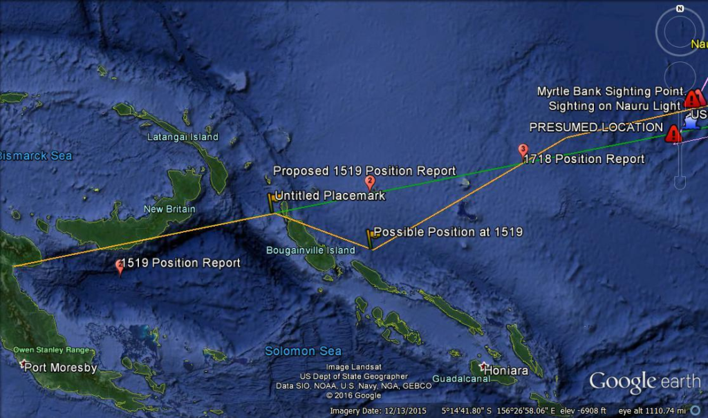
5. This is our rendition of the portion of the flight from Lae to Nauru. As you can see there is a detour and the most likely reason was to avoid weather. We came to above conclusion based on the position report given at 1519 Local (0519 GMT):
This message has always been view as a mistake. The above picture shows the position as reported just south of New Britain. We feel that the operator simply inserted a decimal point where one wasn’t intended. Did Amelia say 150 point 7 or did she say 157? The latter makes far more sense. We couple this with the increased altitude of 10000 feet (probably to avoid hitting Mt. Balbi, 8907’ that is situated in the northern one third of the Bougainville Island) and the message makes perfect sense. This weather was forecast in the weather reports she had received the day before from Fleet Base Pearl Harbor and are confirmed in the reports received at the time of her take off that she never received.
She had been warned the day before by Fleet Base Pearl Harbor:
Avoiding a large thunderstorm was very prudent, but just another warning to turn back. The position plotted puts her 101 SM south of course adding an extra 44 miles to her journey. With the favorable winds she got by the zig-zag, it added only an extra 13 minutes to her time enroute. We consider this a link in the chain because the sun would set in 38 minutes. Because of his exact positioning on the intended course line and his habit of giving expected positions a half hour in advance, it is highly probably that this position report was an estimate given a half hour earlier when they were midway between Frindsbury Reef and the course line. Their indicated overshoot (31 SM) of the course line is within tolerances for celestial navigation. The weather was a warning of things to come. Another wasted chance to turn back to Lae.
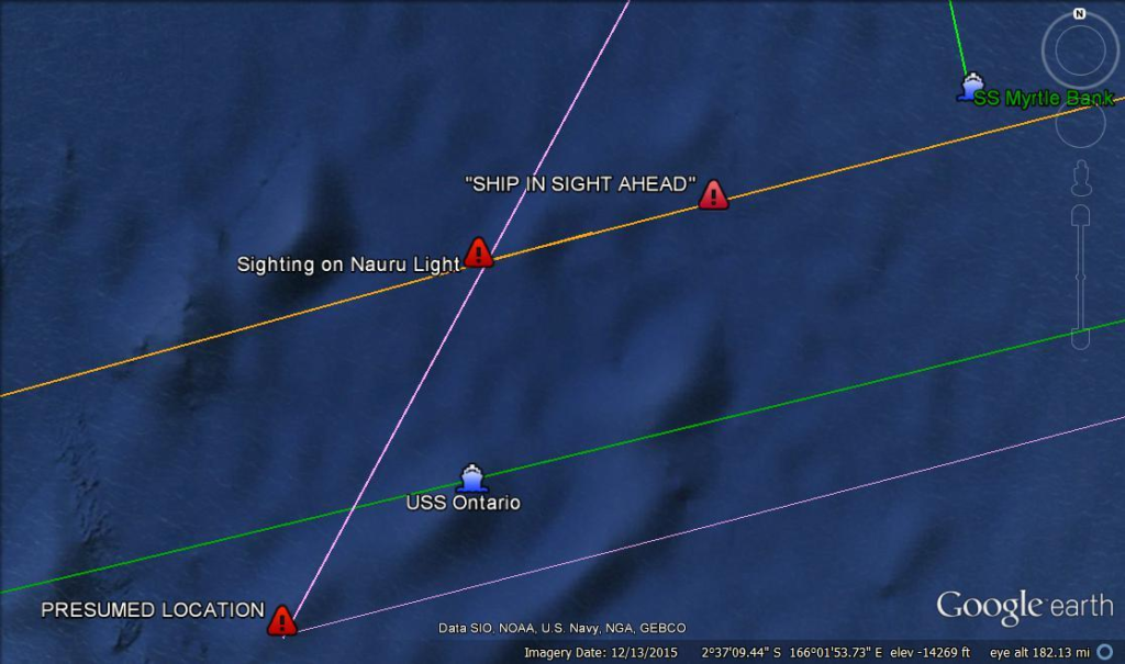
6. This is the point everything came together and created the 6 link in the chain. The drawing above shows what we feel happened. The triangle labeled Sighting on Nauru Light was where he was when he sighted the top of the light over the horizon. It was 4 hours after sunset, because it was a moonless night, this was the first light they had seen. They have run into the weather that the USS Ontario had reported, 80% cloud cover. We know they were below the cumulus clouds in the vicinity because they were able to see the SS Myrtle Bank a few minutes later. No moon, no stars, the Nauru light was their only navigation aid. Because of the difference between the actual height of the tower and what he was told in the NOTAM, he would have placed his position at the triangle marked PRESUMED LOCATION. This assumption would have indicated that his wind calculations were off and they had strayed south of course. At this time they are already 40 miles north of course. The actual flying time between the actual sighting position of the Nauru Light and Howland Island was 8 hours and 42 minutes. Because of his error, he would have estimated his ETA to Howland Island as 9 hours and 22.
They had no contact with the USS Ontario, so they didn’t have an exact location, only a general area. It is not difficult to assume that when she radioed “Ship in sight ahead” they both believed they had seen the USS Ontario when, in fact, they were looking at the SS Myrtle Bank, a freighter bound for Nauru It is interesting to note that at this point in time, if she had turned back to Lae she would have arrived there at 0435 Local time, with a 5 hour fuel reserve. It would have been 1 hour 50 minutes till sunrise, so she would have had to wait until daylight to land. She still had a chance to break the chain.
7. By the time the Electra reached the 337/157 sunline at 1912 GMT, all the past mistakes became apparent. Of course they couldn’t see Howland Island so they probably turned northwest on the sunline. 16 minutes later she reported that she was circling or listening. At this point she would have been 38 miles northwest of her 1912 position or 123 NM NW of Howland. There have many studies on what occurred in the radio room of the Itasca. It is a model of what not to do if you’re trying to save someone’s life. The radio operators, especially Chief Bellarts, did their best to make things work, but the insistence of Commander Thompson to keep the radio room using -11+30 GMT instead of GMT as stated by Amelia Earhart, made for a great deal of unnecessary confusion. The Commander states in his cruise report that the visibility to the north and west was excellent to the horizon (10 NM), but beyond that there were heavy cumulus clouds. To get an idea of how ridiculous the time was Itasca was using, -1130 GMT, Howland Island was using PST which was -1030 GMT and Earhart was using GMT. In the last transmission, her voice seemed to be high pitched; they assumed it was from stress. Referring to the Chater report:
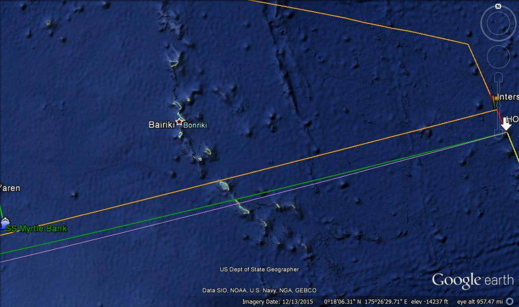
We use TIGHAR’s paper entitled the 3105 Donut to illustrate that to be strength 5 her signals had to be more than 80 NM’s from the Itasca. At 1928 GMT we feel sure that she was 123 NM northwest of the Itasca and Howland Island. At this point in time 1930 GMT she most likely climbed back to 8000 feet and decided to proceed to her alternate, the Gilbert Islands. At 2013, still keeping to her transmission schedule, she stated “We are on the line 157/337 we will repeat message on 6210 KCS” She also is credited with saying “we are running on N ES S line” At this point she is doing her best to keep them alive. We believe she turned to a heading of 278 degrees and headed for Bairiki in the Gilbert Islands. Because they had no idea at this point where they were, that would be as good a heading as any. She must share the blame for this link in the chain with Commander Thompson. We don’t know what she said when the Itasca was broadcasting when they should have been listening.
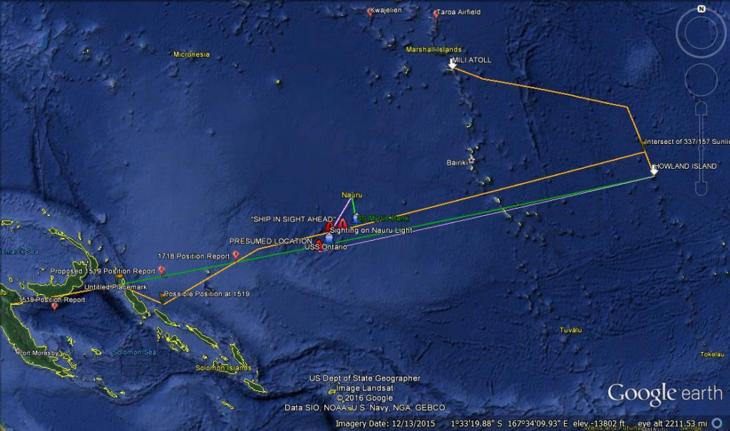
8. We managed to calculate that the plane was at or near fuel exhaustion, which was 25 miles from Mili Atoll. We feel that she would only have missed the area where witnesses said she came to earth by 5 miles. She would have glided 15 miles from 8000 feet. The extra gas needed to keep her engines running amounted to 1.25 gallons. We feel strongly that the estimate of the fuel in her 100 octane tank at Lae could easily have been off by that much.
So there you have it. For better or worse there is result of our research. It makes Richard Spink’s theory plausible. We, as you know, have completely disregarded TIGHAR’s Gardner Island theory and totally unsupportable. The crash and sink theory, what one might refer to as the easy way out, is also full of holes. Fred Goerner and Richard Spink, along with Woody Rogers, and many others have chosen to believe the only theory that has anything to support it: the reports of eye witnesses.
REMEMBER: TAKEOFFS ARE OPTIONAL, LANDINGS ARE MANDATORY!


Amelia contacted a person who occasionally channels interesting people who have something they want to say. According to her, she drowned in the water and it was very cold so easier to let go instead of continuing to struggle. If you’re interested see Revealing Light Tarot by MaryAnn out of Australia. You can find her on YouTube.
I read Fred Goerner’s book many years ago and now he’s passed away so I guess he has his answers.
Jan, thank you for your comments. We will check out Mary’s theory and are open to all possibilities.
Thanks for the good read ! My dad, who was born in 1912, remembered this. He said that the search for her, as per FDR, was extensive. According to Manning, she had a tendency to drift to the left which makes sense why they were off course. Fred could of been drunk / hungover at the time they left Lae so it would be possible he was unable to get exact readings.. idk.. I’ve always thought they’d been captured due to the many witnesses that saw her on various points in the Marshall Islands. To me, most of THIGARs theories are not substantiated. True they found artifacts, but at one point, Garner island had been inhabited so those items could have belonged to anyone. Keep up the good work, this story has fascinated me for years !!
Thank you for your comments. The Earhart mystery tends to capture and hold many people, especially me. I agree with your theory about drifting off course. Yes, Noonan may have had a “few” before leaving Lae. So may questions, so few answers.
Hi. Thank you for a very interesting article. I am re-creating the flight using state of the art Flight Simulation and I have generated an accurate GPS flight plan based on Clarence William’s reciprocal flight plan that Amelia was believed to be using. I have included the two position reports and I can say definitively that the navigation was not the problem. I used Fred Noonan’s ‘deliberate error’ method when they realized the direction finder did not work about 200 miles out. Interestingly this ends up on a line of 154 -334 degrees through the final Waypoint 15 and Howland Island. Waypoint 15 is just 27 miles away from the destination so the flightplan was perfect and also it is correct that Amelia should be on 157 degrees.
So now I can model weather, fuel usage and any other scenarios. What is a puzzle at the moment is the exact Lat Long Location for the USS Ontario. Do you have any firm data on this? Thanks again for a great article
We have been using 2 degrees 59′ 15.46″South 165 degrees 19′ 46.85 East